
Home / Research / China’s double body: infrastructure routes and the mapping of China’s nation-state and civilization-state
China’s double body: infrastructure routes and the mapping of China’s nation-state and civilization-state
Published: February 4, 2019
•
Eurasian Geography and Economics Volume 59, 2018 - Issue 3-4
Abstract
In contemporary China, there are two cartographies that underlie geographical imaginations of China’s political, economic, and cultural nature. The first is the geobody, a bordered notion of the state that stresses national territorial integrity and draws attention to historical territorial transgressions. The second is the civilization-state, a cartography that stresses extensive civilizational connection over national borders and which draws from China’s ancient cosmopolitan heritage and projected developmental future. This article analyzes the cartographies and attendant discourses of the geobody and civilization-state as iconic representations that speak to different ontologies of China. Analyzing China’s double body reveals two drastically different expectations about borders and infrastructure connectivity. Today and in the early years of the Chinese nation, maps of China’s internal railway network have supported nationalist calls for territorial security and promoted the idea of the Chinese geobody. Contemporary maps of the civilization-state, however, stress an unbounded China looking to enrich its neighbors through cultural exchange, road and railway expansion, and Belt and Road Initiative infrastructural connection. This article argues that these cartographies are not reducible to one another and that geographers should take seriously the affective work of maps beyond that of the geobody in critical geopolitical analysis.
Regions
Themes
Cite This
Grant, A. (2019). China’s double body: infrastructure routes and the mapping of China’s nation-state and civilization-state. Eurasian Geography and Economics Volume 59, 2018 - Issue 3-4. https://doi.org/10.1080/15387216.2019.1571370
Full Text
Introduction
Geographers have tied the contemporary surge in border hardening rhetoric and practices such as wall building to a shift in the role of borders from lines of formal demarcation to zones of control where the distinction between the nation and purportedly dangerous “others” that threaten the nation’s political and economic security is articulated (Jones and Johnston 2016; Rosière and Jones 2012). The international nation-state system facilitates this focus on bordering differentiation that separates what is within from what is without the nation; this system is deeply entwined with the dominant cultural imaginary of the geobody, the cartographic representation of the nation-state that works to affectively attach national groups to the political territories that claim to represent them. Geobodies are not, however, the only possible organizing cartographies of states. Cartographies that stress open borders and flows of bodies and capital can also be found in America, Europe, and elsewhere in the world. This divergence in the imagining and mapping of the state reflects domestic political disagreement as well as unresolved ideas about the very being of the state – what it is, who belongs to it, and where it ends.
Such an ontological split can be read in contemporary cartographies of the People’s Republic of China (PRC). On the one hand, officially and privately produced patriotic maps stress China’s formal border lines and play an important affective role by reminding Chinese people of historical and contemporary threats to the national geobody. On the other hand, politicians, popular writers and filmmakers promote representations of China in which the country is defined less by its borders than by its boundless reach. This article shows that China’s double body, that is, the simultaneous assertion of a territorial understanding of the Chinese nation-state and the promotion of a civilizational notion of China that stresses routes over borders, reveals the key role of cartographies and the geographical imaginaries produced by and productive of them in shaping both the geopolitics of contemporary China and in highlighting an ontological split in China’s relationship with the external world. There is no monopoly on mapping China today; both bodies highlighted in this article can be found in official documents, recent “China’s Rise” commentary, in popular culture, and in political, economic and cultural explanations of Chinese history. Above all, the bodies can be found in maps of China that emphasize either China’s delimited national geobody or a cartography of spatial extension.
Indebted to somatic analogies in political theory that highlight functional interconnections between people, territory and healthy political function (Rasmussen and Brown 2005), the first body described in this article, the geobody, grounds an apparently natural and necessary connection between the cartography of the nation-state and the life of the nation. Because borderlands and border provinces are the regions where the geobody is most exposed to its outside, borderlands often loom large in discourses of threats posed to the nation from the outside (Billé 2014). An important but often overlooked aspect of this somatic analogy is the vivifying effect of transportations routes, such as railways, in making nation-states functionally and internally dependent. In the late 19th and early 20th centuries, railway infrastructure played a formative role in the creation of the modern Chinese territory. This article will examine the role of railways, particularly in borderlands, in constituting the national geobody.
The second body examined here is that of the civilization-state, which, as its name suggests, is based upon a civilization rather than a nation. Both Chinese and non-Chinese writers and politicians have discussed China as a civilization-based state that escapes the typical definitions and expectations of the nation-state in key ways, most notably how China envisions and acts toward other states (Zhang Weiwei 2010; Jacques 2009). Recent cartographies of China that stress Chinese civilization over the nation use images of border-spanning routes, roads and railways to explore historical cultural connections and presage the economic linkages that China’s Belt and Road Initiative (BRI) is in the process of realizing. Borderless maps, popular in Chinese media and tourism, also promote imaginings of a China that is more than just another nation-state. The key contentions of this article are twofold: first, that the geobody does not have a hegemony on geographical imaginations in contemporary China; secondly, that maps of the national geobody do not have a monopoly in their potential to animate politics through their affective relationship with publics. Maps of civilization-states or other non-national spaces are also potentially powerful in this way.
The paper is divided into five sections. The first section discusses theories of state bodies, exploring the relationship between the cartographies and geographical imaginings of China’s nation and civilization. Then the article examines China’s geobody in relation to railway construction since the late 19th century. Early foreign involvement and interference in railway development gave impetus to Chinese nationalists to push for building a territorially-integrated railway system. I argue that railways played a key formative role in China’s national geobody due to the humiliation, risk and even potential they brought to the early Chinese nation-state. The following two sections explore “Silk Road” and travel cartographies that ground the Chinese civilization-state. These are closely linked to imaginaries of BRI development, high-speed rail technologies and travel mobility on highways. Unlike in maps of the geobody, in these emerging cartographies infrastructure pathways are no longer vectors of anxiety or the crucial necessities of national integration. Instead, they bridge past and future by emphasizing the contributions of cosmopolitan Chinese civilization in a world of mutual economic and cultural exchange. The final section shows how China’s unbounded civilization-state triggers cartographic anxieties in its neighboring states, demonstrating the mismatch that occurs when different state ontologies rub up against one another.
Historical research on railways in this article is based upon secondary sources. Research on maps and BRI discourse is drawn from primary sources in Chinese and English. I selected sources that were representative of over-arching trends. They were gathered during the course of several trips to China between 2013 and 2018. Methodologically, the article uses critical discourse analysis of both geopolitical rhetoric and cartography (Ó Tuathail and Agnew 1992; Harley 1989). The paper also takes seriously the ontogenetic nature of maps (Kitchen and Dodge 2007) which not only do work in the world, but do work differently depending on context and terms of engagement. Denis Wood (2010, 6) has likened maps to engines “that convert social energy into social space, social order, knowledge.” Understanding the work that maps do is crucial for grasping the stakes of incommensurate cartographic bodies.
State bodies
States can have more than one body. In the United Kingdom (UK) and the United States (US), the recent revival of “populist” politics has contributed to recent policy shifts toward the hard boundedness associated with the national geobody. This has included the privileging of national citizens over the refugees and economic migrants that are imagined to threaten the state, as well as criticism of trade global neoliberal policies that are perceived to disproportionately help other countries (Agnew and Shin 2017). This populist turn draws upon ingrained common-sense notions of a homology between national territory and national society, and the popularized bordered cartographic form of that homology – the map of the national territory (Billig 1995; Agnew 1994). In populist politics, the cartography of the nation-state reinforces only one possible imaginary of the UK and the US, that of the nation, rather than, for example, the globe-spanning British Empire or the expansive Manifest Destiny that undergirded unofficial American Empire at the turn of the 20th century.
Contemporary populist maps reiterate Westphalian cartographies that were first created in Europe but then spread throughout the world during the 19th and 20th centuries with the rise of nationalism (Anderson 2006). Winichakul Thongchai (1994) has famously demonstrated the move from one state body to another, arguing that the transition to modern mapping played a crucial part in the construction of nationhood in Thailand. A shift in the representation of Thai political space guided the transition from a non-Euclidean symbolic space that represented Buddhist cosmology and non-exclusive tributary relations to the cartography of the politically exclusive Thai nation-state. Thongchai (1994) calls the map produced through modern boundary-oriented cartography, the geobody.
The Thai geobody became a powerful “fetishistic” sign of nationhood in modern Thailand, achieved through blending “indigenous or traditional” aspects of Thai history and society with modern nationalism (Thongchai 1994, 133). In books and maps used in schools and state organizations, depictions of historical changes in national territory were narrated anachronistically from the boundaries of the contemporary geobody. In this way, the royal indignity of dynastic tributary loss became transmuted into national pain inflicted by external enemies who, in one guise or another, still loomed at Thailand’s borders.
William Callahan’s (2009) account of modern maps of Chinese territorial loss have similarly narrated historical indignities into attacks on the nation. Widely published maps of foreign states’ dismemberment of the Qing Dynasty have been used in Republican and Post Reform China to allege anachronistic “national” humiliation and call for national unity in the face of external threat. These maps draw citizens' attention to territorial appendages that lie vulnerable at the nation’s borders, encouraging affective and patriotic connection to the geobody. More than a way of rearranging history, the geobody is a somatic metaphor that casts territorial loss as mutilation and dismemberment and is deployed in compelling imagery, such as those of Republican era textbooks that portray China as a mulberry leaf being eaten away by the worms of foreign imperialists (Xu 2016).
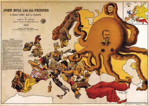
The rise of the somatic metaphor in cartography is cotemporaneous with biological understandings of modern nation-states as beings with functionally differentiated industries organized within national borders. For instance, Émile Durkheim (1997 [1893], 103–104) wrote that “the tearing away of a province from a country is to cut away one or several organs from the organism.… Such acts of mutilation and such disturbance necessarily provoke lasting wounds whose memory does not fade.” Following this bodily logic, maps from the 19th and early 20th centuries satirized geopolitical struggles as a tangle of caricatured human and animal bodies (Barron 2008). These maps used the metaphor not only to represent national bodies, but to portray threatening extensible empires as monstrous and irrational bodies: the Russian Empire was often portrayed as an octopus (see Figure 1), its tentacles representing railway branches greedily and invasively threatening neighboring states (Kosonen 2008).
Figure 1. A humorous map portraying Russia as an octopus strangling its neighbors. Credit: Library of Congress, Geography and Map Division.
This brings us to the other body that will be discussed in this paper, that of the civilization-state. While the somatic metaphor has grounded maps of the Chinese nation-state, Chinese cartographers and writers who focus on Chinese civilization do not create maps of China as an invertebrate imperial body, but as a political being that is positive and beneficial. This approach offers an alternative to either the atomistic nation-state or the exploitative empire.
Since the end of the Cold War, the concept of civilization has been widely deployed to explain regional differences and geopolitical competition. For Samuel Huntington (1996), whose ideas have become popular in both the West and in China, civilization reflects deep-set “cultural identities” in which history, politics, language and religion are bundled together into geographies that spill over contemporary national boundaries. Compared to realist politics in which nations are relatively consistent in how they differ – that is, in terms of their geobody cartographies, flags, national languages, etc. – civilizations are, in this understanding, essentially different from one another, and their intractable differences may lead to cultural and political incompatibility between civilizations (Bassin 2007).
The shift toward a more unbounded and civilizational view of China has gained traction in the 21st century. Tim Oakes and Carolyn Cartier have explored the growing number of official and popular perspectives that look at China and Chinese civilization as a geographic mosaic that reflects thousands of years of dialectical frontier interactions (Oakes 2012; Cartier and Oakes 2010). Others have explored how Chinese officials and citizen intellectuals are rooting Chinese political culture in its past civilization and arguing that it will favorably reorder world politics and economic trade (Agnew 2012; Callahan 2012). These perspectives not only shift geographical imaginations away from a focus on the national geobody, they also promote the idea that China and the civilizations that it interacts with have always had much to gain from geographic connection and cultural and economic interchange and the resultant technological and knowledge enrichment.
The positive reappraisal of China’s extensive civilization resonates with earlier explorations of the political and economic potential of Chinese transnationalism. Aihwa Ong and Donald Nonini (2003) have used the concept of China as an “ungrounded empire” in order to emphasize how border-spanning communication and economic linkage has united a “Chineseness” that goes beyond the territory of any one nation-state. They have argued that Sinophone elites have proposed that geographically mobile essentialist traditions, such as “connections” (guanxi) and Confucianism, unite Chinese populations living across East Asia, Southeast Asia and elsewhere. Wanning Sun (2005) has also argued that Sinophone media plays an important role in sustaining transnational Chinese identity in communities with vastly differing local political and social contexts. Because these accounts focus on the Chinese nation beyond an imagined national homeland, the resultant Chinese imaginary is extensive; however, it remains rooted in the nation. Whereas transnationalism uses culture to account for connections between dispersed members of the national body dwelling within other nation-states, civilization uses culture to recast China as a sui generis civilization that interacts with, and enriches and grows from, its neighboring civilizations.
This civilizational turn is no doubt appealing because European concepts of nation and empire are difficult to map directly onto the Middle Kingdom’s historic political systems (Dirlik 2015; Wang 2013). Shu-mei Shih (2011) has argued that writers often fail to acknowledge China’s own imperial tendencies as concepts such as “colonialism” and “empire” are discussed as though they are proper only to the West. In practice, colonialisms of various types have shaped Chineseness throughout Asia, and Sinophone writing is as complex as the “protean, kaleidoscopic, creative and overlapping margins of China and Chineseness” that defy simple location or definition (Shih 2011, 710–711). This approach not only challenges the hegemony of a monolithic Chinese culture, it also moves beyond nation-bound vocabularies such as diaspora in order expand understandings of what and where China is.
What Chinese civilization is and how the Chinese civilization-state acts is difficult to discipline into any single understanding. Discussing Chinese exceptionalism in International Relations Theory, William Callahan (2013, 37–38) has argued that the rhetoric of unique Chinese civilization “is intertwined with the dominant schools of realism, liberalism, and idealism.” The result is a Chinese-inflected version of Western theoretical models rather than something wholly different. Chih Yuan Woon (2018) has criticized historiographies of Sino-exceptionalism, as they obscure thousands of years of Chinese disharmonies as well as the modern Chinese state’s tendency to act pragmatically to resolve conflicts (see also Fravel 2008). When cultural and tourist visions of civilization are also considered, civilization becomes a polyvalent concept with incommensurate temporal and spatial referents. What these understandings all have in common, however, is an orientation toward something different from the status quo, whether this is found in historical Silk Road routes or the possibility of an interlinked global economy that China will broker and build. Civilization, civilization-states and civilizational maps should be taken seriously for both, for how they go beyond realist paradigms and how they deeply animate diverse segments of Chinese intellectuals, politicians and the public (Callahan 2016).
These emerging discourses have serious implications for cartographies of China. Whereas Thongchai (1994) emphasized the near complete victory of the geobody over non-Western or indigenous epistemologies of mapped space, in contemporary China, Sino-centric cartographies are today being revised in modified forms to help narrate and naturalize new understandings of Chinese civilization and politics. To understand how this is done, it is important to pay attention to how maps, as signs, operate as political and cultural technologies. Ben Anderson (2006, 175) has argued that one of the most politically effective mapping representations is that of the logomap, a “pure sign” that has no informational purpose beyond serving as an immediately recognizable symbol of political and social belonging. Nation-state maps are often portrayed in a solid color, seemingly floating in a space where there is nothing beyond their national boundaries. This cartographic representation is a smooth space that creates an easily recognizable meta-sign that can be used on flags, in textbooks and in all sorts of media. A key way that nation-states are imagined and realized as spatially bound communities is through a population’s affective investment in the logomap of the nation-state, the geobody.
Maps of the nation-state are not the only iconic maps. For instance, logomaps of empires and civilizations can also connect audiences to recognized political formations, but not necessarily with the same type of affective resonance that national geobodies rouse. Old European imperial logomaps represented imperial space in color swashes that were consistent with their Westphalian metropoles, such as the pink wash of the British Empire (Anderson 2006). Yet the lands of these colonial empires were sold and swapped; their territories were hardly geobodies of an integrally linked national community. Furthermore, contemporary logomaps of Chinese civilization employ infrastructure including roads, railways and ports to signify a geographic extensiveness that necessitates reaching across international boundaries. The focus on infrastructure routes and neighboring territories contrasts with national geobodies’ prioritization of boundaries and internal space. The cartography of the Chinese civilization-state offers an ontological difference from that of the geobody because it bypasses somatic anxieties, crossing over boundaries to depict infrastructural connectivity as the basis of civilizational health.
Despite the borderless suggestions of the civilizational logomap however, geobodies and their fears do often still dominate at national boundaries. For the states that neighbor China, Chinese economic influence and demographic presence within their national territories can aggravate a sense of cartographic anxiety, a concept that, according to Franck Billé (2016, 11), “arises from the perceived misalignment between a political imagination of separateness and the reality of a cultural, ethnic, and economic continuum on the ground.” As China’s BRI investment and infrastructure connections are coming into being, the state’s growing borderlands presence is creating concerns among its neighbors that China may be weakening territorial sovereignty (Saxer and Zhang 2017; Billé 2015). The final section of the article will explore cartographic anxieties over an extensive Chinese state body and objections to this characterization.
Constituting the national body: railways and foreign threats
In the history of developing, securing and even endangering China’s national geobody, railway infrastructure looms large. Constructing a national railway system has gone hand-in-hand with creating the nation-state and its cartography. Through a discussion of two maps, one historical and another contemporary, this section demonstrates how China’s national railways have played and continue to play a key role in the creation of the geobody.
Connecting China through transportation infrastructure has long vexed Chinese officials and modernizers. Liang Qichao saw China’s geographical divisions as deeply ingrained and related to the gap between mobilities in Northern and Southern China, in which the culture of the former was based around the Yellow River and the latter around the Yangtze River. These east-west flowing rivers had relatively little inter-basin interaction, and, he argued, North and South China developed cultures around their own axes of interaction (Young 1988, 43–44). Uniting and modernizing China would require bridging this socio-spatial gap. From the late Qing through the Maoist periods, railroads were the most important new transportation infrastructure in China and would carry the burden of uniting Chinese territory. Railways carried the bulk of freight and passenger traffic and formed a geographic mesh that only in the late 20th century a modern highway network has begun to significantly supplement (Li and Shum 2001).
Since they were first introduced to China, railways have provided successive Chinese regimes with political and economic opportunity and risk. During the early years of railway infrastructure development, when railway technology came from Europe, Qing and Republican governments sought to negotiate loans from foreign banks and to establish terms for shared railway management with foreign powers. Chinese governments were largely unsuccessful in attaining fiscal or operational control. In 1911, foreign lenders managed over 90% of China’s railways, and by 1930, railway loans were responsible for half of China’s foreign debt (Davis 1991).
Many officials in late Qing and Republican China realized the importance of building railways for territorial defense (Leung 1980). Ma Jianzhong, a reformist official with close ties to the famous Qing modernizer Li Hongzhang, called for railway construction to repel foreign encroachment: “Only railroads will be able to annihilate (foreign) appetites for our frontiers and to provide protection for our country. Therefore, I appeal that we must construct them and permit no delay” (Ma 1994, quoted in Chin, 2013, 212). A nationally unified rail system would, however, remain elusive. During the Qing period, the power of local governments and merchants to tax or be shareholders in rail systems resulted in a patchwork of privately owned rail systems oriented toward local profit (Leung 1980), while during the Republican period, continuous warfare and regional Balkanization precluded the construction of a national railway system.
The railway financing and construction that did occur was connected to foreign states’ colonial interests in China. After China’s defeat in the Sino-Japanese War in 1895, foreign powers began a geopolitical “battle for concessions” in which foreign imperial powers built railway networks into the hinterlands of treaty ports with the goal of selling goods and exploiting resources. The rapid appearance of foreign designed and managed railways in Qing territory contributed to the Boxer Rebellion of 1899–1901, during which Boxers destroyed railroad tracks near Beijing, which they viewed as symbols of foreign imposition (Leung 1980). In the final years of the Qing Dynasty, rights recovery associations fought against state policies seeking outside borrowing to finance railways. In a climate of anti-foreign sentiment, these associations saw foreign financing as well as Manchu Qing centralization of railways as threats to the Chinese nation and to local economies. Rights recovery literature called for “breaking the loan agreement and protecting the railway” (poyue baolu), and used somatic analogies in which foreigners were portrayed as threatening to stop the circulation of metaphoric life blood in China’s railway lifelines (mingmai) (Rankin 2002, 339–341).
Foreign involvement in railways has contributed to China’s contemporary discourse of national humiliation and cartographic dismemberment, as is demonstrated in the popular press historical volume Maps of the Century of National Humiliation. The book features a map entitled “Road Authority Seized from China by the Imperialist Powers” and a table that includes what railway privileges foreign powers obtained and the lengths dozens of railways built or planned by England, France, Russia, Japan and Germany between 1898 and 1914, including the Yunnan–Vietnam Railway and the Manchurian Railways. An entirely unbuilt Tibetan Railway is also listed, its presence on the table suggesting that the phantom railway’s mere conception was a bodily transgression (People’s Press Map Room, 1997, 59–61).
Indeed, these historic railways did facilitate foreign interventions into Qing borderlands that nationalist modernizers were increasingly claiming as part of China’s integral national territory. For example, in 1896, negotiations between Russia and the Qing Empire led to the laying of the Russian-administrated and controlled Central Eastern Railway (CER) through Qing Manchuria. Eventually, the Russian military took control of municipalities near the railway, including a southern extension into the Liaodong peninsula (Glatfelter 1991). In 1905, the Japanese military took control of the CER south of Shenyang. The “Mukden (Shenyang) Incident,” a deceptive explosion along the Japanese controlled railway, would be the pretense for the Japanese Empire’s invasion of Manchuria. By 1945, the Japanese military had seized and utilized many of the railways built in Manchuria and the coastal provinces, in effect turning China’s railways against China (Leung 1980; Sun 1955).
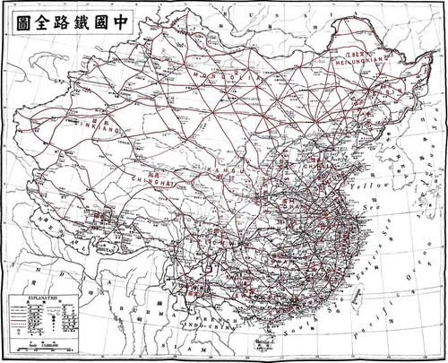
The early history of railway infrastructure in China was never viewed as wholly negative; Chinese reformers and modernizers recognized transportation infrastructure as a key tool for building a nationally integrated and modern China. In 1922, Sun Yat-sen (1922) published the book The International Development of China with the purpose of attracting foreign investment for China’s economic development. A major focus of the book is constructing a national railway system to cover the entire country. “A grand, evenly spaced rail grid” would help China unite, populate, and make economically productive the whole of Chinese territory (Edmonds 1987, 426). Sun’s book contains a map of the proposed national railway network; its rail lines appearing in a deep arterial red (see Figure 2). The cartography excludes neighboring countries. This vision for China’s national development would not be realized during Sun’s time, but the dream of a nationally integrated railway network would persist.
Figure 2. Sun Yat-sen’s plan for a national railway system. The railroads are marked in a vivid red. Credit: (Sun 1922).
The PRC has invested heavily in creating a national Chinese transportation infrastructure. Mao Zedong’s national development strategies aimed to eliminate spatial contradictions between China’s regions, and the early PRC’s railway system reflects this project (Leung 1980). After the Sino–Soviet split, railway construction and development in general shifted to inner and western China, where a Chinese core located far from its potentially severable border provinces would allow the country to be more resilient in the case of Soviet or American attack (Naughton 1988).
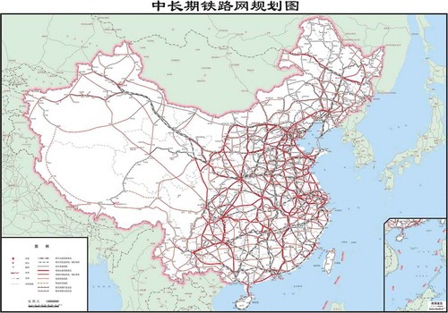
The National Development and Reform Committee’s current national railway masterplan works to shorten interurban transportation times and improve transportation efficiency. It also uses a grid-like design that aims for maximum areal coverage. Main transit routes adhere to four north-south and four east-west (sizong siheng) lines that allow for high-speed rail travel between distant sites like Xiamen and Ürümqi. The plan aims to increase spatial coverage by achieving a “balance” (junhang) in the distribution of China’s railway network, focusing on regional development and rejuvenation (zhenxing). National defense is not mentioned, but the plan emphasizes the efficient circulation of people and economic activity that will make China prosperous. Figure 3 shows the 2016 iteration of the national rail system, its railway arteries (dadong mai) colored a deep red like in Sun Yat-sen’s 1922 map (National Development Reform Commission 2016).
Figure 3. This map from 2016 shows the Chinese state plan for a national rail system as it will be in 2030. The integrated system focuses on the national territory. Credit: (National Development Reform Commission, 2016).
Railways in China during the 19th and 20th centuries brought both opportunity and fear. Railway infrastructure could be used to promote China’s development and defend it from imperial exploitation, but it could also put Chinese governments into debt, enable colonial exploitation and facilitate military invasions. The destruction of railways during the Boxer Rebellion and the presence of railways in the discourse of national humiliation suggests how these avenues for national integration and prosperity can become vectors of cartographic dismemberment. While railways seemed to promise development for the early Chinese state, railway arteries could also bring poison into the national geobody, threatening Chinese sovereignty through foreign management and financial pressure and imperiling Chinese territory through external invasion. The washes of pink ink that have marked the dismembered flesh of border provinces in national humiliation maps, largely overlap with areas that included early railways. The bordered geobody maps that Callahan (2009) discusses came to be popular during the Republican Period, and again as part of the Patriotic Education curriculum in the 1990s, therefore owe much to memories of railway manipulation.
Working to strengthen the geobody within national boundaries, PRC officials have constructed and continued to improve a centralized national railway system that promotes internal connectivity and balanced territorial development (Edmonds 1987; National Development Reform Commission 2008). Discourses of the geobody continue to warn against the negative impact of external meddling within the national transportation system. For instance, while waiting for my Chinese train to change its wheel bogie to adjust to different track gauges at the Sino-Mongolian border crossing of Erenhot, an event that speaks both to historical differences in railway development and nation-states’ continued security fears over the possibility of foreign military trains crossing national borders, I read an anxiety-tinged article about railways in a state-published magazine.
Among numerous articles promoting trade and transport, the Logistic Times published an attack on the Soviet Union for dismembering (zhijie) Outer Mongolia from China. It also critiqued contemporary Russia for castrating itself (huidao zigong) by selling off its national railway shares (Yang 2015). This example illustrates how geobodily metaphors both remain part of infrastructure discourse and also work to remind the Chinese population of the potential dangers of unfettered mobility. Yet this inward-looking geographical imagination does not fully account for understandings and mappings of transportation connectivity in contemporary China. The following two sections will explore cartographies and geographical imaginaries that eschew the national geobody and posit instead a spatially expansive Chinese civilization.
Constituting the civilizational body: unbounded cartographies
Like those of the national geobody, maps of China’s BRI infrastructure plans often flatten topographical contours in order to convey a sense of spatial homogeneity. Rather than emphasize national territorial unity that terminates quickly at state boundaries, however, they emphasize instead civilizational connection grounded in transportation routes. The world appears as a smooth space for the movement of capital and development opportunities with international borders largely dissolved. Notions of Chinese civilization that look to ancient trade networks and China’s historic role as a confident political, cultural and technological center, both reinforce and are reinforced by such BRI cartographies. These cartographies are part of a greater shift in which Chinese writers are forgoing inward-looking perspectives of China and embracing China’s historic geographical extendedness as a model for the future (Woon 2018; Oakes 2012). In these recovered cartographies, China’s geographical reach is conjured as a force of global revitalization.
At the heart of many of these discussions is how Chinese civilization will remake a world in which it increasingly has power and influence. Gungwu Wang has proposed that western concepts like nation, empire and sovereignty are of limited use in analyzing China’s political history. Wang (2013, 133) suggests that for many Sinophone writers, the concept “All under Heaven” (tianxia) expresses “an abstract notion embodying the idea of a superior moral authority that guided behavior in a civilized world,” rather than an empire. The political theorist Tingyang Zhao (2012) writes that China’s recovery of its central political position will allow it to offer the world an international political system based on the ancient All Under Heaven system. Rather than adhere to the current international system of nation-states, this model calls for a world institution in which states harmoniously strive for “Confucian improvement” (Zhao 2009, 18; Zhang 2015). Mapped representations of the All Under Heaven system often use concentric circles to represent the cascading levels of authority that flow from the state’s moral center, a model found in indigenous cartographies throughout Asia (Thongchai 1994; Tambiah 1977).
The most popular maps that look back to China’s past, however, are maps of China’s contemporary Silk Road infrastructure development plans. These maps use historical trade connections as templates for emerging transportation routes throughout Eurasia and can be understood as aspirational cartographies that stress connection and the equal status of involved states while subordinating national boundaries. Since 2013, China has promoted two different types of Silk Roads under one umbrella project called BRI, which literally translates as One Belt, One Road (yidai yilu). Footnote1 The BRI includes a number of routes arranged around the overland “Silk Road Economic Belt” that travels through Eurasia and the “21st Century Maritime Silk Road” that extends from the South China Sea into the Indian Ocean.
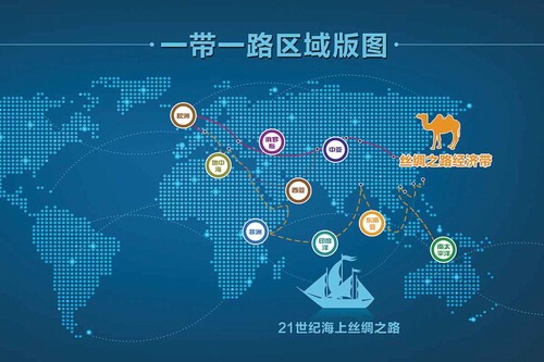
BRI cartographic representations emphasize not a bounded geobody, but a frictionless world of global economic integration. Produced by media and businesses, the maps reground the cartographic ontology of China, revealing it not as a country jealously guarding its borders, but a facilitator and leader in economic development. When these maps do show nation-state divisions, they often lack colors or shading to differentiate national territories: borders are downplayed and infrastructural connectivity is emphasized. Figure 4 shows an exemplary BRI stock image produced in China. The abstractions of the belt and road routes and the iconicity of the camel and ship make the map easily identifiable, a logomap that circulates alongside those of the national geobody. Whereas maps of the BRI blur the distinction between internal and external, those of the geobody emphasize and preserve this binary.
Figure 4. This Silk Road logomap privileges routes over borders and world regions beyond Asia. This map was for sale on the image website “Red Movement,” whose primary audience is stated to be government agencies. The Chinese labels read: “One Belt, One Road Regional Map,” “Silk Road Economic Belt,” and “21st century maritime road.” Credit: designed by Li Mao.
The production of popular cartographies of the BRI speaks to the ubiquity of civilizational discourse about Silk Road development and the power of maps to condense and shape for a wide audience, a geographical imagination that is ontologically different from that of the national geobody. While Weidong Liu has emphatically stated that no government offices have produced the BRI logomaps that are so popular in both domestic and international imaginations of China’s Silk Road projects, the Chinese state has certainly been active in not only describing specific transportation infrastructures and potential routes, but also in emphasizing civilizations and civilizational connectivity in official Chinese geopolitical discourse.Footnote2
In his speeches, Chinese President Xi Jinping has consistently deployed the concept of civilization in relation to the Silk Road, the BRI and global economic development. Official publications expounding Xi Jinping’s views on civilization insist that its orientation is toward harmony rather than the “clash of civilizations’” (wenming chongtu) thinking said to dominate in the West (Zhao and Deng 2015). This rhetoric builds upon Hu Jintao’s (2005) promotion of the Confucian-inspired concept of the “harmonious world,” (hexie shijie), which was pitched not simply at states, but at different civilizations. On 27 March 2014, Xi Jinping (2014a) delivered a speech at UNESCO headquarters in which he emphasized the worldwide benefits of exchange and mutual learning between civilizations. Stating that civilizations are richly diverse, equal and inclusive, he stressed that “the Chinese civilization, working in harmony with the civilizations created in countries around the world, will provide mankind with spiritual guidance and energy.” While delivering a speech on civilizational heritage at UNESCO, an organization best known for preserving historical sites, is perhaps unsurprising, Xi continuously looked back to civilizational exchange as he has promoted the BRI project, development banks and bilateral relations.
Many of the moments of interaction Xi cites relate to particular moments of exchange and interaction that occur along historical trade and travel routes that linked Chinese civilization to these places. In a visit to Turkmenistan, Xi (2014b) spoke of the diplomat Zhang Qian, who was credited with bringing “Blood sweating horses” through Central Asian mountain passes to the Central Plains during the Han Dynasty. In a speech to the China International Friendship Conference, Xi (2014c) emphasized the mutual enrichment that tolerant and inclusive connectivity can have, stressing that when China opened the overland Silk Road over two thousand years ago, the peoples of every country it linked benefited. Furthermore, when Zheng He led the world’s greatest fleet to the Pacific and Indian Oceans six hundred years ago, he scattered the seeds of harmonious friendship in 30 countries and regions, rather than violently seizing them. For Xi (2014a), invasion and colonialism are nightmares (mengyan) alien to Chinese civilization.
Rather than bring a nightmare to the world, BRI is part of the realization of the Chinese Dream (zhongguo meng), which Xi says will not be limited to China, but to the dreams of all peoples around the world (Xi, 2014c). The idea of the Chinese Dream, which President Xi framed in March 2013 as the rejuvenation of China through the creation of a strong and economically prosperous state, includes infrastructural projects that extend to and beyond China’s borders. A collected volume of speeches and publications on the topic also cites the Qinghai-Tibet Railway dream, the submarine dream and the aircraft carrier dream, among other oneirisms (Ren 2013).
Notions of the positive transformative potential of transportation infrastructure can also be found in popular literature. In Weiwei Zhang’s (2010) book China Shock, the author presents a vision of Eurasian civilizations that China’s rise could assist in revitalizing as powerful “civilizational states” (wenming xing guojia), such as Rome and Islam, which, despite their present division into nation-states, are here discussed as essentially united by their respective civilizational traits. Zhang (2010) rejects the idea that civilizational states should use Western states as models. Just like Confucius does not need Plato’s approval, Chinese civilization does not need the approval of other civilizations to attain glory. Because China’s expansive territory is more historically integrated than that of states of similar sizes, such as Russia and Canada, China can drive the global economy using its advantageous location and attain a radial regional strength (Zhang 2010, 67).
In practice, this radial strength will be achieved through infrastructure, and this infrastructure will be an expression of China’s civilizational accomplishment. In May 2017, Beijing Foreign University surveyed exchange students from 20 countries involved in the BRI, asking them to select China’s “Four New Great Inventions.” The students’ selections were shared bikes, online shopping, cashless payment and high-speed rail (Chao Hui 2017). Because these technologies all have forbearers in other countries, the survey results, which were widely publicized in China after Ali Baba Chairman Ma Yun discussed them, are best read as part of the narrative on renewed Chinese civilizational aspirations rather than actual foreign perceptions of China. The implication is that Chinese technological perfection of the new inventions could be as transformational on a civilizational level as the original Four Great Inventions were in ancient times; high-speed rail will diffuse through Silk Road connections just as paper and gunpowder once did.
Over the past decade, high-speed rail services have spread throughout China. As of 2015, 19,000 km of China’s 121,000 km of train track were high-speed lines (National Development and Reform Commission 2016). Domestically, the Chinese government has been adamant about using joint ventures to acquire and improve upon high-speed rail technologies such as powered cars, reversing the humiliating practices of China’s early encounter with railways. China’s Railway Bureau requires technology transfers, preferential prices and rights to use Chinese product names from approved foreign partners (Gao 2012). Moreover, the railways make material China’s recent civilizational accomplishments. Zhang Weiwei (2010) insists that China’s high-speed railway technology is an example of China’s ability to set a standard that other advanced states will look up to. As he explains, it is the mark of a “civilizational state” to have technological and economic standards that other states follow (Zhang 2010, 118–119).
Confidence in China’s historic virtue as a civilizational force for good as well as its renewed technological primacy are discourses that allow Chinese politicians, media and writers to propose that China is resuming its historical, political and cultural role. They are also encouraging Chinese people to project new maps in which borderlands anxieties tied to infrastructural invasion are secondary to border-spanning Silk Road routes. The next section will further explore the popularity of route-based logomaps by looking at how they are used in tourism and popular culture to imagine the Chinese people as explorers of untamed frontiers.
Constituting the civilizational body: traveling routes
In popular culture, the historic routes that brought earlier Chinese travelers to places that are now either within China’s frontier territories or beyond them have attracted popular attention. The promotion of these routes in tourist discourse and the publication of maps depicting them are key ways that the civilization-state is taking hold among the Chinese population. These pathways echo those that Xi Jinping (2014a) emphasized in his UNESCO speech, such as those taken by China’s Western Han Dynasty diplomat Zhang Qian, the Tang Dynasty traveling monk Xuan Zang and the Ming Dynasty diplomat (and sometimes pacifier) Zheng He. They are promoted in popular books, in museum exhibits, by local tourism boosters and also in China’s Silk Road-themed international exhibits, such as the models of Zheng He’s ships included in the China pavilion at the 2017 Astana World Expo (see also Blanchard 2017).
Historical routes at China’s periphery are being dusted off and promoted as part of a greater effort to put China’s civilizational heritage to contemporary use. Interest in the contemporary Silk Road has led to the rebranding of historic trade routes, such as a railway bridge that links Tongjiang, China to Leninskoye in Russia’s Jewish Autonomous Oblast, a connection labeled the “Black Dragon [Amur] River Silk Road Belt” (Zhang 2015). Elsewhere, provincial and local officials are reviving ancient trade roads into service as tourist attractions, including the “Tea-Horse Road” that links Yunnan Province to Tibet and the “Tang-Tibetan Ancient Road” that links Shaanxi Province to Tibet and beyond. These ancient unpaved pathways are being reimagined through the Sichuan–Tibet and Qinghai–Tibet Railway connections, as well as a proliferation of roads routes that China’s expanding highway system is enabling.
The modernization of China’s highways and the continued growth of car ownership in China is creating a new market for pleasure-oriented cartographies. Tourist maps of western China printed on sepia-toned paper and beige cotton obscure national boundaries as they emphasize mobility. In the maps seen in Figure 5, found in a tourist shop in Lhasa, the lines representing interlinked Chinese and Nepalese highways prove to be thicker than demarcations of national boundaries.
Figure 5. These maps are all printed with the following quote from the Ming Dynasty painter Qichang Dong: “Read thousands of books and walk thousands of miles” (Ch. du wan juan shu xing wan li lu), suggesting that each map purchased discloses one of innumerable routes to be experienced. Credit: designed by Scroll of Directions. Photo by author.
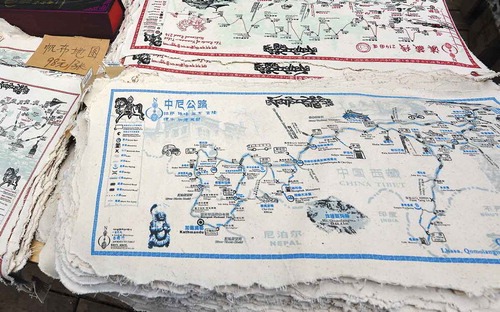
When I visited Lhasa in 2018, I purchased a handbook of Tibetan road maps that contained no provincial or national boundaries at all. Instead it depicted roads edging on what would be, to a national geobody, stretches of land perilously close to disputed boundaries. These maps, some of which are consciously based on historic trade routes, ground a Chinese culture and modern Chinese subject rooted in a long tradition of exploration at the frontiers of Han Chinese civilization. Roads and the mountains, monasteries and hot springs that may be seen from them prove to be much more important than the vital claims to frontier lands found in Sun Yat-sen’s geobody map of China’s western railways.
This trend accompanies an embracing of the exoticness of China’s distant “Western Region” (xiyu), an ancient geographic term being recycled for contemporary use. For instance, in the summer of 2015, an exhibit at the Shaanxi History Museum contained a large raised relief map showing a reconstruction of the path that Zhang Qian, the man who retrieved the blood sweating horses, traveled through Central Asia during the 3rd century BC. The topographical map shows his travels extending as far as the Caspian Sea (see Figure 6). Like other civilizational logomaps, this map does not illustrate any political divisions, but simply used lights to illuminate the progress of Zhang Qian’s mission as it “cut a path through the Western Region”. Such path-oriented maps are common in popular treatments of other appropriated historical cultural ambassadors, such as Zheng He.
Figure 6. Raised relief map of Zhang Qian’s Central Asian journeys. Lightbulbs at the top of the map mark the progress of his journey. The characters on the bottom mark the Himalayas. Credit: photo by author.
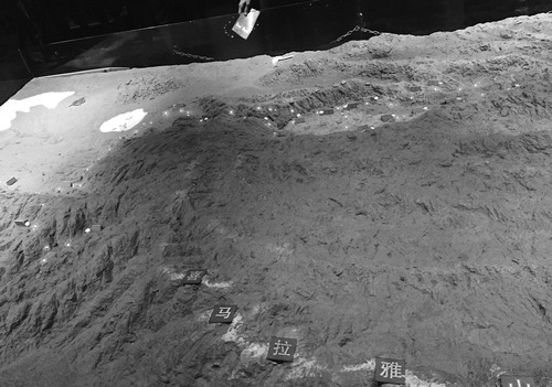
Unlike the more recent administrative “West”, the “Western Region” through which Zhang Qian traveled is a more expansive concept that indexes the unboundedness of China’s borderlands. In classical Chinese works, the Western Region is a place where Chinese presence brings civilization, and its absence marks isolation and backwardness (Millward 1998). The Tang Dynasty poet Wang Wei evocatively described the end of civilization at one of the last Chinese outposts in Gansu’s Hexi corridor: “Where the road reaches the most remote Yangguan, there is nothing but smoke from the fires of barbarians and dust from beyond the pass.”
In recent years China’s borderlands have been imagined as itself a crucial place for Chinese culture to be renewed or reinvigorated (Oakes 2012). The mapping of borderlands as a partial terra incognita, known and experienced through its roads, is an act of drawing from the cultural repertoire of the xiyu in order to make it alluring again for modern and mobile Chinese travelers. Contemporary travel writings recover the solitude and adventure of China’s far-flung places, where intrepid individuals must carve their own paths out of the trackless landscapes beyond Chinese civilization. In the recent book Ten Years on the Road, the writer Diansheng Lei (2012) embarks on an epic journey through the topographically uneven and occasionally hostile environs of China’s internal frontiers, taking as inspiration the journeys of fellow traveler Xu Xiake, whose own itinerary brought him to the difficult margins of southern China during the Ming Dynasty. Xu Xiake’s own journeys have recently been recounted in a book whose cover art shows an antique-looking map that bears only the most experiential of routes: the map includes rivers and settlements but lacks any political boundaries or even mountains to distinguish impediments to his mobility. The publication and availability of the works of these authors and others, both ancient and modern, demonstrate that the Chinese people come from a long tradition of frontier exploration, following difficult roads on itineraries that take them to edges of the unfamiliar.
Routes are also connected to Chinese travelers’ engagement in civilizational exchange. Contemporary materializations of the Tang–Tibetan Ancient Road memorialize historical trade and travel connections between China, Tibet and Nepal, as well as the Tang Dynasty Princess Wencheng’s journey to Lhasa. Narratives from Chinese sources credit the adolescent Princess as bringing civilization to Tibet through the importation of ideas such as astrology and Buddhism and goods such as medicine, tea and new crops (Powers 2004, 32–33). Today, Wencheng’s journey is being staged for tourists in a massive five act opera that promotes the idea of a long-standing and harmonious relationship between China and Tibet (Denyer 2016). The opera reenacts the tribulations that Wencheng and her retinue faced on the wild Plateau, showing them tottering along a mock-up road before finally being welcomed in the spectacularly staged urban landscape of Lhasa. This is a journey that reflects the contemporary tourist’s rugged self-imagining of their own Tibetan sojourn as well as individual Chinese travelers’ potential for harmonious exchange.
I was continuously confronted by advertisements for this opera in Lhasa, where boosters promote it as one of the city’s top sights, on par with Potala Palace and the Barkor. The journey of Wencheng has become so iconic in narratives of China’s presence on the Tibetan Plateau that a site from her journey on the Tang–Tibetan Ancient Road even features on Starbucks’ mugs. Though recent iterations of Wencheng and her journey can be labeled nationalist propaganda, it is crucial to recognize that they emphasis civilizational connectivity and share discourse with BRI projects. In this register, they serve as edifying examples of China’s benevolence and the potential of the civilization-state to bring mutual prosperity.
The expansion of China’s highways and the development of its domestic tourism industry have whetted appetites for more travel at its frontiers. In so doing, geographical imaginations have looked back to China’s civilizational past in order to render distant places exotic and mysterious. Travel cartographies share many similarities with those promoting the BRI: they focus on routes rather than boundaries, and facilitate border-spanning movement rather than focusing on internal/external difference and threats from beyond the border. They are also linked to the geopolitics of the civilization-state by promoting harmonious cultural exchange while avoiding discussions of conflict and violence. The next section will explore how the legacy of the geobody leads to cartographic anxieties in China’s neighboring states, where Sino-centric borderless logomaps have not been enthusiastically embraced.
Cartographic anxieties between the geobody and civilizational body
While China’s extensible cartographic body emerges, bordering states have to balance economic opportunity with cartographic anxiety. Despite the expansion of Chinese media outlets’ foreign-oriented reach in order to counter prejudices and conjure a sympathetic global audience through soft “symbolic power” (Sun 2009), China’s extensive geopolitical and geoeconomic BRI project produces perceived misalignments of national sovereignty. Martin Saxer (2016) has highlighted how deals to build infrastructures between Central Asia and China have produced cartographic anxieties even as long simmering border disputes are being settled. Neighboring countries that are cooperating on development projects with China are working to assert their own territorial sovereignty, their officials unsure of Chinese designs in the region (Murton, Lord, and Beazley 2016; Diener 2015). Indian politicians, businessmen, and members of the public have expressed unease over China–Pakistan and China–Sri Lanka transportation corridors that would surround Indian territory and threaten India’s regional interests. In response, the Indian government is promoting a civilizational trade project of its own: the Indian Ocean oriented Project Mausam (Palit 2017). In Mongolia, cartographic anxieties during the era of BRI include suspicions that the PRC could revive the exploitation and colonization of Mongolia during the late Qing Dynasty (Jackson and Dear 2016).
These anxieties partially stem from what Sidaway and Woon (2017) have called unease over the “interimperial” nature of China’s Silk Road. Such fears can be encouraged by BRI maps that include states with which China has no historic Silk Road connections or which threateningly highlight China’s central role in the BRI by coloring in its geobody on an otherwise borderless routes logomap. Although Chinese officials and scholars have been put on the defensive against foreign press accusations that China’s Silk Road projects are economically self-serving or exploitative, earlier European imperial designs to use transportation infrastructure to expand colonial projects in Asia haunt China’s contemporary Silk Road (Sidaway and Woon 2017).
This defensiveness, in which writers insist that the Chinese state is incapable of copying Europe and being either imperial or colonial, obscures an earlier awareness in the PRC about the European origins of the term “Silk Road.” During the Maoist era, the Communist Party held that the Silk Road was not essentially Chinese, but a European ruse used to open China’s territory to imperialist exploitation. Early attempts at South-South Afro–Asian cooperation were based in part around a repudiation of the “so-called” Silk Road. This state of affairs only changed after the US–China détente in 1971, when the Chinese state began adopting a view of the Silk Road that embraced cultural interaction over economic and political threat (Chin 2015; Kuo 2017). The contemporary Chinese civilization-state has selective amnesia in this regard, thus shielding it from accusations of imperialism and potential threats to neighboring geobodies.
Cartographic anxiety also stems from bellicose writings coming out of China. Outspoken citizen intellectuals like the retired PLA colonel Liu Mingfu (2015) discuss competition between civilized great powers in terms of classical geopolitical struggle. In such writings, Huntingtonian readings of “civilization” appear in the guise of nation-state centric realist geopolitik, even if China is said to have the capacity to bring about a more civilized and peaceful global order. These writings suggest that the rhetoric of China’s benevolence thinly veils territorial revanchist and military expansionism. China’s ongoing island building and fortification in the South China Sea have gone hand-in-hand with the online circulation of a map of China that shows the nation’s territory in a blood-like red and proclaims: “China: not even a drop can be lost” (Zhongguo: yi dian dou buneng shao).
As foreign press and scholarship has grown skeptical over China’s Silk Road economic strategy, sympathetic scholars have rejected border-spanning belt and road logomaps, even despite their harmonious promises. Weidong Liu and Michael Dunford (2016, 336) have argued that the goal of BRI is to forego cartographic limitations as an “open cooperation network without a spatial boundary that includes, but is not limited to, the ancient Silk Roads.” For them, the BRI must instead be understood as a multitude of topological connections, including education exchanges, financial investments and interurban links. This collapsed geographic space seems to eschew any maps at all, promising a new type of “inclusive globalization” that forms a fundamental challenge to exploitative neoliberal globalization (Liu, Dunford, and Boyang 2017). These writings echo the tropes of mutual benefit, civilizational equality and harmony found in the speeches and writings of 21st century Chinese politicians and citizen intellectuals. The anti-cartography they propose can be seen as the apotheosis of the movement away from bordered space in its move to reduce cartographic anxieties over China’s BRI projects.
Resisting cynicism about China’s economic schemes, many states are embracing China’s BRI development programs and receiving loans to build railways, roads and other infrastructural projects from Chinese funding sources such as the Export-Import Bank of China, the Asian Infrastructure Investment Bank and the Silk Road Fund (Liu and Dunford 2016). Xinhua News (2017) reported that PRC state-owned railway enterprises were working on 20 foreign projects exceeding a value of $15 billion in late 2017, building on the hundreds of foreign projects that they have completed in recent years and serving as the new calling card for “China Made” products. In addition to profits for the consortiums, tens of billions of dollars in financing and loans have been negotiated for railway construction across Africa and Central Asia (Ford 2017; Morlin-Yron 2017; Tan 2015). A “Pan-Asia Rail Network” connecting China to several Southeast Asian countries is also coming into being with the assistance of Chinese planners, banks and railway consortiums (Martin 2016).
Conclusion
This article has made the case that China has a double body. The first, the national geobody, is properly a body in the sense that it draws from the powerful image of an organic body. When it is mapped, boundaries are its most salient features and transportation infrastructure is rendered as part of a vital network that keeps the geobody alive. Infrastructure and the geobody have always been interlinked, both dating from the late Qing and Republican periods, in which railroad construction facilitated not only national integration, but also fears about foreign invasion and financial control. Logomaps of China that emphasize national boundaries and transportation infrastructure continue to be made today. Infrastructure routes have also played a key role in China’s other body, the Chinese civilization-state. This second body claims to use the transformative potential of increased exchange and trade in a world not of anxious, quarreling nations but of diverse civilizations. Logomaps of civilization de-emphasize international boundaries and embrace the connectivity of BRI infrastructure. In Chinese tourism and popular culture, we can also find cartographies that emphasize highways and roads, blurring boundaries between internal and external and embracing a cosmopolitanism of China’s past.
Unbounded connections worry China’s neighbors. Cartographic anxieties emerge because of the “misalignment” between national boundaries and border-spanning economic and cultural influence (Billé 2016). Such anxieties are proper to somatic analogies, so it is perhaps misplaced to imagine, as Parag Khanna (2016, xxiii) has, that boundary-spanning infrastructure is “the arteries and veins, capillaries and cells, of a planetary economy underpinned by an infrastructural network that can eventually become as efficient as the human body.” Stitching the globe together with a somatic metaphor can also raise the specter of potentially disastrous mutilation, such as in descriptions of the South China Sea’s shipping lanes as “vital arteries of trade” in articles about disputes over maritime access.
Territorial conflicts in the seas of East and Southeast Asia pose a difficult scenario for the emergence of China’s second body. China is using classically Westphalian practices to extend its territorial claims, making island reefs habitable land and issuing maps with a nine-dash maritime boundary (Rolf and Agnew 2016). In his analysis of China’s maritime conflicts, Christian Wirth (2016) has largely collapsed the territoriality of the geobody with that of civilizations, arguing that “civilizational boundaries” defined by the East/West dichotomy are important flashpoints between China and the US backed status quo. Yet, as this paper has argued, civilization-thinking in China exceeds narrow geopolitik and takes seriously imaginings of China’s cultural extensiveness and the power of infrastructural connectivity to unite civilizational difference. While the great irony of the South China Sea conflict is that it has emerged in a time of greater economic connectivity, it is a mistake to reduce China’s second body to its first and turn national boundaries into civilizational boundaries.
Methodological nationalism, reinforced by the nation-state system and the tendency for scholars and analysts to focus on nationalist identity and territorial sovereignty, makes it hard to take civilization-states seriously, even when their maps are being examined. If China always has a geobody, it seems to follow that it will always act as a nation-state. But logomaps of nation-states are not the only maps that animate politicians, citizen intellectuals, the media and members of the public. Maps of civilization-states can also stir the imagination and, when engaged in on their own terms, can reveal fundamental challenges to the nationalist cartographies and bordered-thinking that dominates politics today. Logomaps drawn around routes and trajectories can make places external to nation-states appear more accessible and familiar, forming a striking contrast to the nightmare of closed borders, walls and fences that excite populism and nationalism today.
This potentially fundamental challenge recalls one of the supposed implications of the rise of the national geobody – that there is no turning back. Winichakul Thongchai (1994) argued that the advent of modern mapping technology played a crucial part in not only creating the national territory of what would become the Thailand nation-state, but that it also changed the way mapping there worked. Maps of the geobody, with their firm divisions between inside and outside, played a key part in creating a Thai national history and identity that fit in with the norms of the nation-state system. According to Thongchai (1994), this rupture also led to the loss of “indigenous” cartographic knowledges as they were subsumed into the ascendant, and eventually totalizing, hegemony of modern mapping and the politico-legal international system that this mapping upholds. But what if efforts to recover past cartographies can be productive of new geographical relations? This paper has argued that in contemporary China maps of the civilization-state are offering ways of imagining geopolitical relationships and interactions in registers self-consciously different from those of nation-states and their geobodies.
More Research
1/2